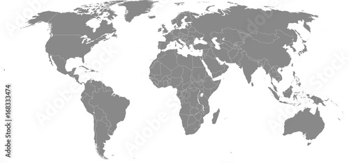
Greeting Cards: High resolution map of the world (without Antarctica) split into individual countries. Showing distinct borders between countries. Robinson projection.
Contributor: JuliusLakatos
ID : 168333474
File Details
Published: 2017-08-18 17:24:32.040875 Category: Graphic Resources Type: Vector Model release: NoKeywords
robinson, earth, map, state, province, cleaving, different, individual, geography, vector, projection, country, country, border, sea, travel, planet, globe, political, nation, north, south, east, west, atlas, asia, africa, america, oceania, europa, silhouette, design, backgroundImage size:
SHARE
Other prints and products

Canvas Prints
30 USD or Credits
Framed Prints
10 USD or Credits
Prints and Posters
5 USD or Credits
Metal Prints
10 USD or Credits
Acrylic Prints
10 USD or Credits
iPhone Cases
30 USD or Credits

Galaxy Cases
30 USD or Credits

Pillows
18 USD or Credits

Duvet Covers
100 USD or Credits

Shower Curtain
50 USD or Credits
T-Shirts
20 USD or Credits

Tote Bags
20 USD or Credits